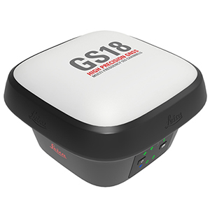
August 26, 2020, Leica Geosystems, part of Hexagon, has unveiled the Leica GS18 I, a versatile, GNSS RTK rover with visual positioning. The GS18 I allows users to capture points of interest from a distance and measure points from the images in the field or in the office.
Visual positioning technology – sensor fusion combining GNSS, IMU and a camera – allows users to reach previously inaccessible or obstructed points safely and efficiently. Visual positioning is based on photogrammetric technology with near real-time data processing, allowing surveyors to check the quality of their data while on site.
 “The GS18 I and the workflow in Infinity opens even more new possibilities for us to capture and measure everything we need. It can help fill the data gaps common with traditional GNSS systems that often require supplemental field locations with a total station to complete an area being surveyed. Now you can have one piece of equipment to carry out several jobs on site with fewer equipment setups,” said Donald Smith, P.L.S., senior project manager and principal at BL Companies. “The survey is performed more efficiently as the GNSS crew can capture all detail, even areas with limited access. No data is missed because points can be extracted through Infinity later in the office.”
The GS18 I continues the success of the tilt-compensated Leica GS18 T rover. In addition to visual point positioning, the GS18 I inherits all the functionalities of a GS18 T, including the ability to map and stake out points with either tilted or levelled pole.
“We designed the GS18 I for surveying professionals who need to measure points that previously could not be measured easily and accurately with GNSS and for those who want to capture the environment quickly and decide later which points shall be measured,” said Bernhard Richter, vice president of geomatics at Leica Geosystems. “With this world’s first GNSS RTK rover with integrated visual positioning technology, Hexagon brings GNSS technology to new user segments while increasing safety, speed and productivity.”
GS18 users can use less time on site and continue measuring points with Leica Infinity software in the office, saving expensive on-site time. If new measurement needs arise, surveyors can measure additional points from the captured images. The GS18 I works with Leica Captivate field software for image capturing, on-site point measurement and quality assurance in the field. Users can go beyond measuring points and create an automatically registered and referenced 3D point cloud from the same images and continue working in other 3D software.
Leica GS18 I GNSS RTK Rover Technical Specifications
| GNSS TECHNOLOGY & SERVICES | ||
| Self-learning GNSS | Leica RTKplus | Adaptive on-the-fly satellite selection |
| HxGN SmartNet Global | HxGN SmartNet Pro | Network RTK and unlimited worldwide RTK bridging and PPP service |
| HxGN SmartNet+ | Network RTK and RTK bridging service | |
| HxGN SmartNet PPP | Unlimited worldwide RTK bridging and PPP service | |
| Leica SmartCheck | ontinuous check of RTK solution | Reliability 99.99% |
| Signal tracking | GPS | GLONASS | L1, L2, L2C, L5 | L1, L2, L2C, L3 |
| Galileo | BeiDou | E1, E5a, E5b, AltBOC, E6 | B1I, B1C, B2I, B2a, B3I | |
| QZSS | NavIC | L1, L2C, L5, L62 | L53 | |
| SBAS | TerraStar | WAAS, EGNOS, MSAS, GAGAN | L-Band, IP | |
| RAIM | Receiver Autonomous Integrity Monitoring | Detection and elimination of faulty satellite signals for enhanced positioning solution and GNSS integrity |
| Number of channels | 555 (more signals, fast acquisition, high sensitivity) | |
| Tilt compensation | Increased measurement productivity and traceability | Calibration-free Immune to magnetic disturbances |
| IMAGING | ||
| Measuring camera | Sensor | Field of view | Video frame rate | Global shutter with 1.2 MP | Hz 80°, V 60° | 20 Hz |
| Image group capture | 2 Hz capturing rate | Max. capturing time: 60 s, size of an image group appr. 50 MB |
| Point cloud | Leica Infinity software | Derive point clouds from image groups |
| MEASUREMENT PERFORMANCE & ACCURACY | ||
| Time for RTK initialisation | Typically 4 s | |
| Real-time kinematic (Compliant to ISO17123-8 standard) | Single baseline Network RTK | Hz 8 mm + 1 ppm | V 15 mm + 1 ppm Hz 8 mm + 0.5 ppm | V 15 mm + 0.5 ppm |
| Real-time kinematic tilt compensated | Not for static control points | Additional Hz uncertainty max 8 mm + 0.4 mm/° tilt down to 30° tilt |
| RTK bridging | Up to 10 min bridging of RTK outages | Hz 2.5 cm | V 5 cm |
| PPP | Initial convergence to full accuracy typically 10 min, Re-convergence < 1 min | Hz 2.5 cm | V 5 cm |
| Post processing | Static (phase) with long observations Static and rapid static (phase) | Hz 3 mm + 0.1 ppm | V 3.5 mm + 0.4 ppm Hz 3 mm + 0.5 ppm | V 5 mm + 0.5 ppm |
| Code differential | DGNSS | Hz 25 cm | V 50 cm |
| Image point measurement | 1-click measurement in field & office | Typically 2 cm – 4 cm (2D1) captured from 2 – 10 m distance |
| COMMUNICATIONS | ||
| Communication ports | Lemo | Bluetooth® | WLAN | USB and RS232 serial | Bluetooth® v4.0 (BLE & BR/EDR), class 1.5 | 802.11 b/g/n for field controller communication only |
| Communication protocols | RTK data protocols NMEA output Network RTK | Leica 4G, Leica, CMR, CMR+, RTCM 2.2, 2.3., 3.0, 3.1, 3.2 MSM NMEA 0183 v4.00 & v4.10 and Leica proprietary VRS, FKP, iMAX, MAC (RTCM SC 104) |
| Built-in 4G LTE modem4 | LTE frequency bands UMTS frequency bands GSM frequency bands | 20, 8, 3, 1, 7 | 13, 17, 5, 4, 2 | 19, 3, 1 8, 3, 1 | 5, 4, 2 | 6, 19, 1 900, 1800 | 850, 900, 1800, 1900 MHz |
| Built-in UHF modem5 | Receive & transmit UHF radio modem | 403 – 473 MHz, channel spacing 12.5 kHz, 20 kHz, 25 kHz, max. 1 W output power up to 28800 bps over air | 902 – 928 MHz (licence free in North America), max 1 W output power |
| GENERAL | ||
| Field controller and software | Leica Captivate software | Leica CS20 LTE or BASIC field controller, Leica CS30 & CS35 tablets |
| User interface | Buttons and LEDs Web server | On / Off and Function button, 8 status LEDs Full status information and configuration options |
| Data recording | Storage Data type and recording rate | Internal memory up to 4 GB, Removable SD card Leica GNSS raw data and RINEX data at up to 20 Hz |
| Power management | Internal power supply External power supply Operating time6 | IExchangeable Li-Ion battery (2.8 Ah / 11.1 V) Nominal 12 V DC, range 10.5 – 26.4 V DC Typical time up to 8 h |
| Weight and dimensions | Weight | Dimensions | 1.25 kg / 3.55 kg standard RTK rover setup on pole | 173 mm x 173 mm x 109 mm |
| Environmental | Temperature Drop Proof against water, sand and dust Vibration Humidity Functional shock | -30 to +50°C operating with camera, -40 to +65°C operating without camera, -40 to +85°C storage Withstands topple over from a 2 m survey pole onto hard surfaces IP66 | IP68 (IEC60529 | MIL STD 810G CHG-1 510.6 I | MIL STD 810G CHG-1 506.6 II, MIL STD 810G CHG-1 512.6 I) Withstands strong vibration (ISO9022-36-08 | MIL STD 810G 514.6 Cat.24) 95% (ISO9022-13-06 | ISO9022-12-04 | MIL STD 810G CHG-1 507.6 II) 40 g / 15 to 23 msec (MIL STD 810G 516.6 I) |
Source : https://www.gim-international.com