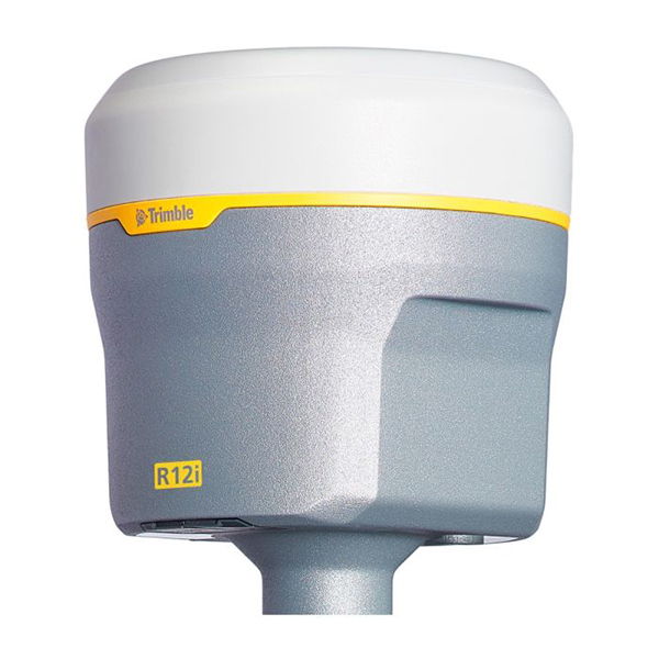
The Trimble R12i delivers unmatched GNSS performance, speed and accuracy to boost your productivity like never before. With improved performance in challenging GNSS conditions and robust Inertial Measurement Unit (IMU)-based tilt compensation that lets you forget about leveling the pole, you’ll get more done faster than you thought possible.
Trimble TIP GNSS Technology
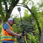 Callibration-free Inertial Measurement Unit based tilt compensation with immunity to magnetic interference. With IMU-based tilt compensation you can easily obtain accurate measurements on obstructed points like building and property corners or utility inverts. Safely capture points in hazardous location like the edge of an open excavation or on roadways with on-screen stake out instruction you can guide the pole tip directly to the design point. It also features build-in automatic integrity monitoring, so you can have total trust in your system with real time IMU anomaly detection and alerts.
Trimble Propoint GNSS Technology
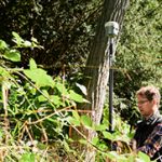 Better RTK & Trimble RTX performance near canopy increased accuracy, reliability and productivity near tree canopy and new signal filtering provides better protection against signal jamming and interference so you can use it in any environment such as near buildings, among trees, urban, or in a mixed tree and urban environment without any difficulties.
Trimble Correction Services
Instant access to RTK-level correction, no base or radio required. With Trimble CenterPoint RTX Correction, satellite delivered high accuracy, quick convergence and trust reliability.
Trimble R12i features :
- Trimble TIP Tilt Compensation Technology
Inertial Measurement Unit (IMU) based tilt compensation for accurate laying out and measuring points without precisely leveling the pole - Trimble CenterPoint RTX Correction Service
Provides RTK level precision worldwide without the need for a base station or VRS network - Trimble 360 Technology
672 channels with support for all available and future GNSS signals, and improved protection from interference and spoofed signals - Trimble xFill Technology
Keeps you working in radio and cellular black spots with continuous RTK coverage
The difference between the new Trimble TIP technology and the legacy Trimble SurePoint tilt compensation technology found in the Trimble R10 and R12
Trimble TIP technology uses an Inertial Measurement Unit (IMU) comprised of three accelerometers and three gyroscopes to provide the necessary information for the positioning engine to precisely determine the attitude of the rover, allowing the tilt heading and thus the position of the pole tip to be computed in real time.On the other hand, Trimble SurePoint technology, first introduced in the Trimble R10, uses a magnetometer to determine the tilt heading. Because the heading provided by the magnetometer depends on an accurate global model of the earth’s magnetic field, and because the sensor itself is susceptible to local sources of magnetic interference which can render it unusable, the achievable tilt angle is less (15°), compensated points cannot be measured in all instances, and the system must remain static when measuring a compensated point. It is therefore also not possible to use Trimble SurePoint technology for stakeout, whereas Trimble TIP technology doesn’t require the system to remain static and is therefore suitable for both measurement and stakeout workflows.
Finally, because Trimble TIP technology uses sensor data to automatically align the IMU to the GNSS reference frame in the field, it is not necessary to perform specific steps to calibrate the sensors, as is the case with the Trimble R10 and Trimble SurePoint technology.
The Difference between Trimble R12 AND R12i
The Trimble R12 and R12i both use the ProPoint GNSS positioning engine, and indeed Trimble TIP technology cannot integrate with previous generations of Trimble GNSS positioning engines as ProPoint is an entirely new generation of software architecture with TIP integration as part of the fundamental design. Trimble ProPoint technology also delivers the robustness required to maintain alignment of the combined GNSS-inertial solution when using TIP technology in challenging GNSS environments. This is applicable for both RTK and CenterPoint RTX surveys.
However, there is one area where the GNSS performance of the R12 and R12i differs which users should be aware of, particularly when working in challenging GNSS environments. When using the Topo point method with the Trimble R12, the ProPoint positioning engine delivers a converging antenna phase center (APC) position solution. This is particularly useful when attempting to measure a point in a challenging environment such as under tree canopy, as the system is able to gradually improve its solution quality once the antenna can be assumed to be stationary.
Source : https://geospatial.trimble.com