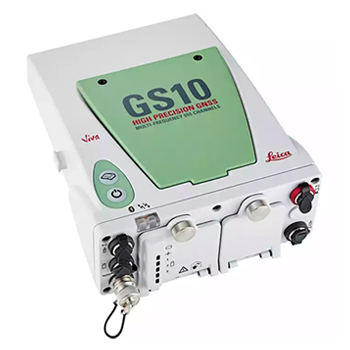
Leica Viva GNSS is a complete range of versatile GNSS solutions for you. From completely integrated, to totally modular solutions,Viva GNSS provides a system to master all of your tasks. The new Viva GS10 makes up part of the new professional range of GNSS solutions. As a direct replacement for the GX1230, the GS10 offers all the flexibility of a backpack solution with all the functionality of the new Viva operating system. The Leica GS10 is the most versatile of the new Viva range and can be configured to be used in many different formats. Often used as a reference station, backpack rover or in conjunction with external devices i.e. mobile mounted or with an echosounder for hydrographic work.
Built on years of knowledge and experience, the Leica GS10 delivers the hallmarks of Leica GNSS – reliability, availability and accuracy.
- Leica SmartCheck – RTK data-processing to guarantee correct results
- Leica SmartTrack – advanced four constellation tracking guarantees most accurate signals
- Leica xRTK – delivers more positions in difficult environments
The Leica GS10 Unlimited is your safe investment for the future.
- Future proof – lean back and observe GNSS modernization with future proof hardware
- SmartLink – bridges RTK communication gaps up to 10 minutes
- GPS, Glonass, Galileo and BeiDou provide maximum performance. Additional support of BeiDou only and Glonass only positioning.
The Leica GS10 is built for the most demanding environments.
- IP68 protection against dust and continuous immersion
- Built for extreme temperatures of –40° C to +65° C
Work as you want to.
Whatever the task in hand, Leica Viva GNSS can do the job.
- Exchangeable communication devices for RTK rover or field base station use (as on pole, mounted on car, quad bike, tripod).
- Integrated web server to configure the logging of Leica or RINEX raw data and measure with one button press in the field.
The Leica Viva GS10 receivers come with the revolutionary Leica Captivate software, turning complex data into the most realistic and workable 3D models. With easy-to-use apps and familiar touch technology, all forms of measured and design data can be viewed in all dimensions. Captivate spans industries and applications with little more than a simple swipe, regardless of whether you work with GNSS, total stations or both. While Captivate captures and models data in the field, Leica Infinity software processes the information back in the office. A smooth data transfer ensures the project stays on track. Captivate and Infinity work in conjunction to join previous survey data and edit projects faster and more efficiently.
The Leica Viva GNSS Unlimited series utilises all useful GNSS signals today. Both technologies SmartTrack and SmartCheck have been extended to fully support the Chinese BeiDou GNSS. GPS, Glonass, Galileo and BeiDou together provide maximum performance.
Leica Viva combines a wide range of innovative products designed to meet the daily challenges for all positioning tasks. The simple yet powerful and versatile Leica Viva hardware and software innovations are redefining state-of-the-art technology to deliver maximum performance and productivity. Leica Viva gives you the inspiration to make your ambitious visions come true.
Source : http://leica-geosystems.com